 Poster Archive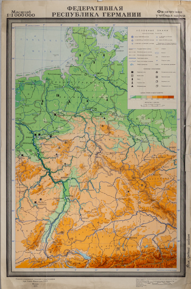
Federal Republic of Germany, map (Russian lang.)
Poster
This image is available only to signed-in users.
Protected by copyright. The poster images are published on the website for non-commercial purposes – for viewing, education and research.
- Identifier
- JS611n
- Category
- P.10. Miscellaneous
- Subject
- P.10. Miscellaneous
- Shelve
- X.10.
- Title
-
en
Federal Republic of Germany, map (Russian lang.)
AI (Unreviewed)
Provenance Translated by mistral-large-latest on 23.04.2026 - Vācijas Federatīvā Republika, karte (krievu val.)
- Year
- 1970
- Author
- unknown
- Publisher
- Ģeodēcijas un kartogrāfijas galvenais direktorāts
- Place
- Moscow
- Method
- unknown
- Dimensions
- 70,5 x 106,5 cm
- Preservation
- 7
- Print run
- 11,000
- Count
- 1
- Language
-
Russian
AI (Unreviewed)
Provenance Generated by mistral-large-latest on 23.07.2026
The poster is a physical educational map depicting the Federal Republic of Germany. The map primarily uses green, orange, and light blue tones to show various geographical regions. The country's borders and administrative units are marked with black lines. At the top, there is an inscription in large, bold letters on a gray background, beneath which is smaller text. On the right side is a legend with various map symbols represented as icons and colors. The map has a coordinate grid with numbers and letters along the edges. Around the map is a gray border frame, and at the bottom is an additional line of text. In the background of the map, bodies of water, mountains, and plains are also visible.
AI (Unreviewed)
Provenance Generated by mistral-large-latest on 21.07.2026; Translated by mistral-large-latest on 22.07.2026
Масштаб
1:1 000 000
ФЕДЕРАТИВНАЯ
РЕСПУБЛИКА ГЕРМАНИИ
Физическая
учебная карта
Главное управление [?] и картографии
при Совете Министров СССР
Москва
1970
[?] подписью [?]
Отпечатано: [?] Москва, [?] экз.
Отпечатано: г. [?] 1-38. Тираж 1000 экз.
[?] [?] Москва, 1-38. Тираж 1000 экз.
[?] г. Москва, 1-38. Тираж 1000 экз.
Отпечатано: г. Москва, 1-38. Тираж 1000 экз.
Для средней школы
1:1 000 000
ФЕДЕРАТИВНАЯ
РЕСПУБЛИКА ГЕРМАНИИ
Физическая
учебная карта
Главное управление [?] и картографии
при Совете Министров СССР
Москва
1970
[?] подписью [?]
Отпечатано: [?] Москва, [?] экз.
Отпечатано: г. [?] 1-38. Тираж 1000 экз.
[?] [?] Москва, 1-38. Тираж 1000 экз.
[?] г. Москва, 1-38. Тираж 1000 экз.
Отпечатано: г. Москва, 1-38. Тираж 1000 экз.
Для средней школы
AI (Unreviewed)
Provenance Generated by mistral-ocr-latest on 23.07.2026
Scale
1:1 000 000
FEDERAL
REPUBLIC OF GERMANY
Physical
educational map
Main Directorate [?] of Geodesy and Cartography
under the Council of Ministers of the USSR
Moscow
1970
[?] signature [?]
Printed: [?] Moscow, [?] copies.
Printed: [?] 1-38. Circulation 1000 copies.
[?] [?] Moscow, 1-38. Circulation 1000 copies.
[?] Moscow, 1-38. Circulation 1000 copies.
Printed: Moscow, 1-38. Circulation 1000 copies.
For secondary school
1:1 000 000
FEDERAL
REPUBLIC OF GERMANY
Physical
educational map
Main Directorate [?] of Geodesy and Cartography
under the Council of Ministers of the USSR
Moscow
1970
[?] signature [?]
Printed: [?] Moscow, [?] copies.
Printed: [?] 1-38. Circulation 1000 copies.
[?] [?] Moscow, 1-38. Circulation 1000 copies.
[?] Moscow, 1-38. Circulation 1000 copies.
Printed: Moscow, 1-38. Circulation 1000 copies.
For secondary school